
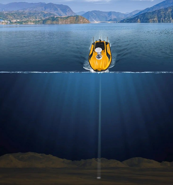
In scenarios such as hydrological surveying, water area engineering operation and maintenance, and ecological environment governance, the precise mapping of underwater terrain is a crucial step in obtaining basic data of water areas. The single-beam mapping module, as a specialized and compatible accessory for unmanned vessels, with its compact integration, precise detection, and convenient operation, seamlessly integrates with Doppler flow measurement unmanned vessels and water quality monitoring unmanned vessels, enabling unmanned vessels to achieve “surface operation + underwater mapping” integration capabilities. It becomes an efficient tool for underwater terrain surveying, water depth measurement, and underwater landform modeling, laying a solid foundation for comprehensive data collection in water areas.
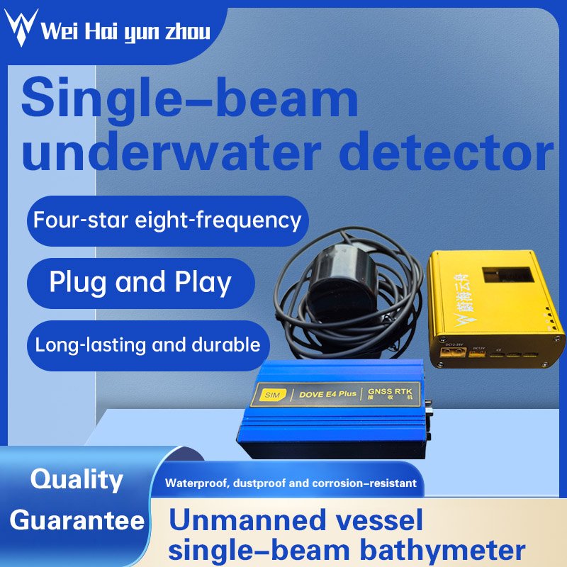
This single-beam mapping module, specially designed by Weihai Arktech Co., Ltd. for unmanned vessels, is deeply adapted to the hull layout, power supply system and operation scenarios of unmanned vessels. It is the key core for unmanned vessels to extend from “surface monitoring” to “underwater perception”. It has three core advantages: professional mapping performance, high adaptability, and strong environmental adaptability. It perfectly meets the lightweight, intelligent and multi-task operation requirements of unmanned vessels.
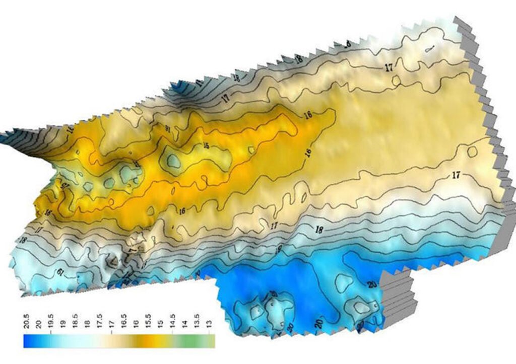
In terms of core mapping performance, the Weihai Yunzhou beam mapping module is equipped with a high-precision single-beam depth sensor. Based on the principle of sound wave reflection, it can achieve centimeter-level precise underwater depth measurement, with a measurement range covering 0.3 – 100 meters, suitable for most inland waters such as shallow beaches, inland rivers, lakes, reservoirs, and near-shore shallow seas. It has high-speed data acquisition capabilities, which can complete real-time water depth detection simultaneously with the unmanned vessel’s cruise. The data refresh rate is high, enabling precise capture of the subtle undulations of underwater terrain and restoring the topographic features of underwater shoals, deep pits, reefs, and sediment accumulation areas. At the same time, it is equipped with professional depth measurement algorithms, which can automatically eliminate measurement errors caused by ship pitching, water surface waves, and water current disturbances, and can also achieve automatic calibration of draft depth and real-time compensation of sound speed, ensuring the accuracy and reliability of mapping data in different waters and environments, and meeting the precision requirements of professional scenarios such as hydrological surveying and engineering design.
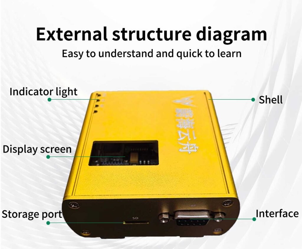
In terms of adaptability and integration, the Weihai Yunzhou beam surveying module is specially designed for unmanned vessels, achieving compact size, lightweight design, convenient installation, and intelligent interconnection. The overall volume of the module is small and lightweight, and no significant modification of the unmanned vessel’s hull is required. It can be quickly installed in the reserved position at the bottom of the unmanned vessel through clamps, screws, etc., without affecting the speed, draft depth, and wind resistance capacity of the unmanned vessel. Power supply and communication adopt plug-and-play design, which can be directly connected to the main control power supply system and data transmission bus of the unmanned vessel, supporting mainstream communication protocols such as 485/CAN. It is deeply linked with the navigation positioning and autonomous cruise system of the unmanned vessel, and the surveying data can be automatically matched with GPS/BDS positioning data, generating three-dimensional surveying data of “latitude, longitude + water depth” without the need for manual secondary integration.
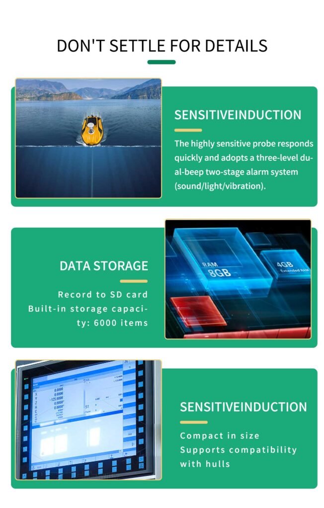
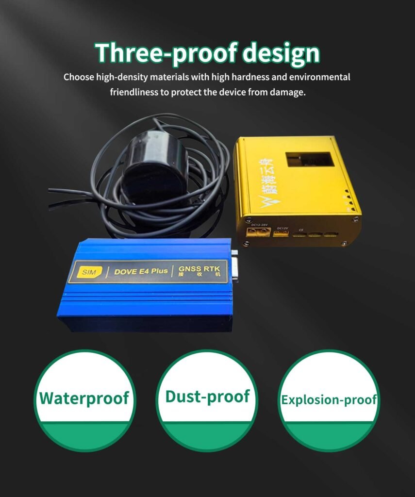
n terms of environmental adaptability and operational convenience, the WaveBeam mapping module of Weihai Yunzhou fully takes into account the waterborne operation scenarios of unmanned vessels. With a protection level of IP68, it can work submerged in water for a long time, resisting corrosion, vibration, and temperature variations, and can adapt to different water qualities such as fresh water and slightly salty water, as well as harsh operation conditions such as high-speed ship navigation and rough water turbulence. It can work without faults for a long time. The mapping data can be transmitted back in real time to the shore-based control terminal of the unmanned vessel, synchronously displaying water depth curves and underwater terrain contours. It supports real-time drawing of mapping trajectories. Staff can intuitively grasp the underwater terrain situation from the shore-based terminal. At the same time, the module supports automatic data storage and format export, and can directly connect to professional mapping software such as CAD, Surfer, and GlobalMapper to quickly generate contour maps and 3D terrain models of underwater terrain, without the need for additional data processing, significantly improving the efficiency of mapping work.
As the golden partner of unmanned vessels, the Weihai Ark beam surveying module, when combined with unmanned vessels, has completely transformed the inefficient mode of traditional underwater topographic surveying – “manual vessel operation + fixed-point depth measurement”. It has achieved unmanned, fully automatic, and comprehensive underwater surveying operations. After the unmanned vessel is equipped with a single-beam surveying module, it can autonomously cruise along the preset route, complete the full-section and full-area depth measurement of the entire water area without human intervention, significantly reducing labor costs; compared with traditional manual depth measurement, the operation efficiency is increased by 3-5 times, and it can easily reach areas such as shallow beaches, narrow alleys, reservoirs, and submergence areas that traditional surveying vessels cannot access, filling the blind spots in underwater surveying; at the same time, the precise positioning ability of the unmanned vessel enables the density and uniformity of underwater surveying points to far exceed manual operation, resulting in more comprehensive and accurate surveying results.
Its application scenarios cover the entire field of water area surveying and management: In hydrological basic surveys, establish precise underwater topographic archives for rivers, lakes and reservoirs, grasp the water volume and water depth distribution, and provide data support for water resource scheduling, flood control and drought relief; In water area engineering operation and maintenance, conduct underwater topographic mapping for waterways, ports, docks and offshore wind power foundations, detect waterway siltation and changes in the surrounding landforms of the foundations, and provide basis for engineering dredging and safe operation; In ecological environment governance, map the underwater topography of rivers and lakes, grasp the thickness of sediment accumulation and the geomorphic characteristics of aquatic habitats, and assist in water ecological restoration and governance; In water conservancy project construction, provide precise underwater topographic data for the design, construction and acceptance of projects such as reservoirs, sluices, and irrigation channels, ensuring the quality of the construction.
From the simple surface monitoring to the comprehensive “surface + underwater” data collection, the beam mapping module of Weihai Yunzhou has enabled a qualitative leap in the operational capabilities of unmanned vessels, making them efficient and intelligent equipment in the field of water area surveying. The deep integration of this professional partner not only promotes the transformation of underwater topographic mapping industry towards unmanned and intelligentization, but also makes water area data collection more comprehensive, more accurate, and more efficient. It provides solid technical support for water research, water conservancy projects, and water area ecological governance, and helps the development of smart water conservancy and water ecological civilization towards a deeper level.